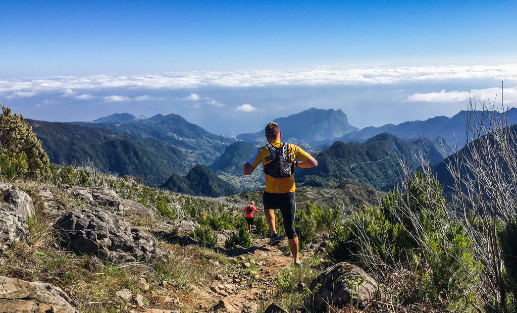
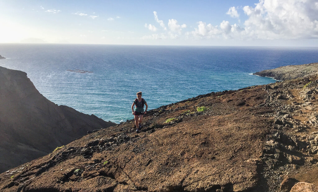
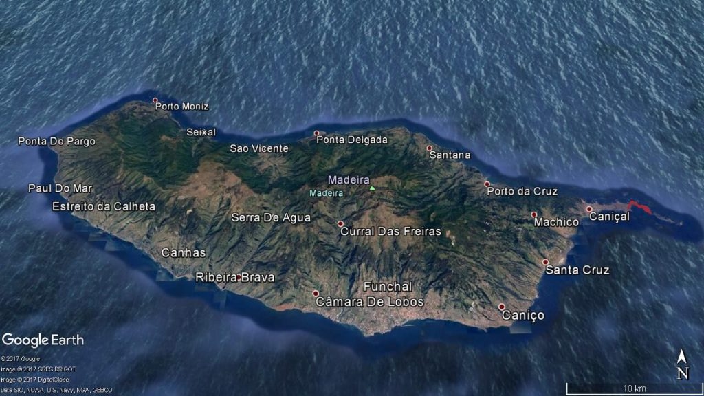
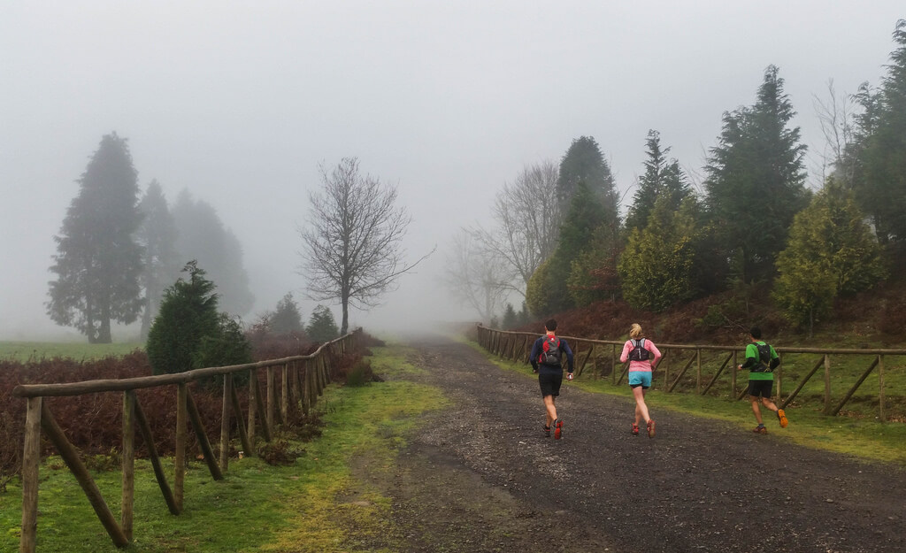
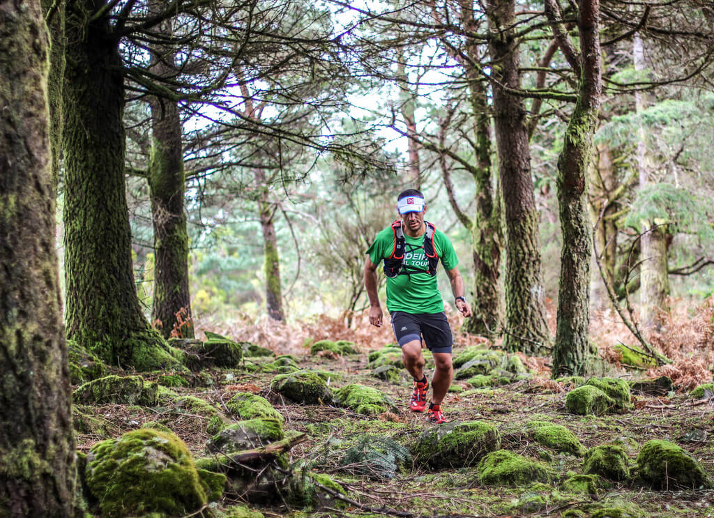
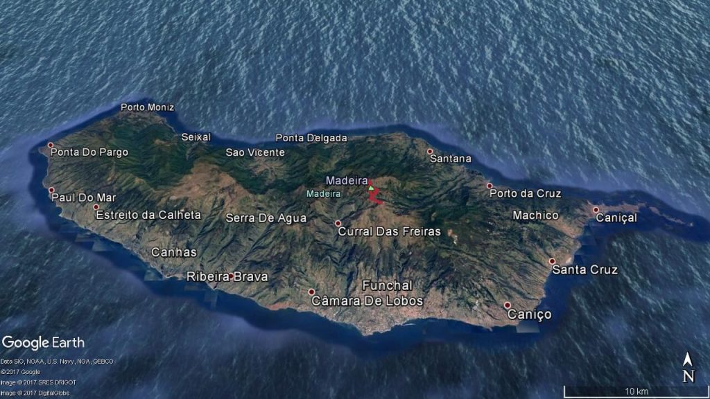
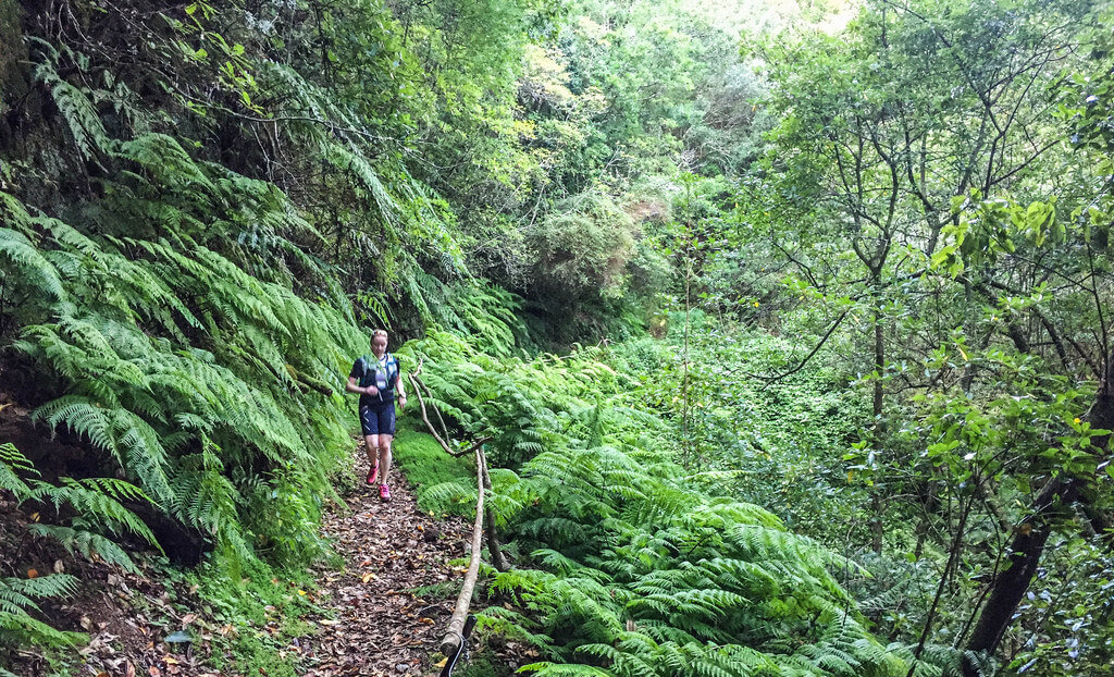
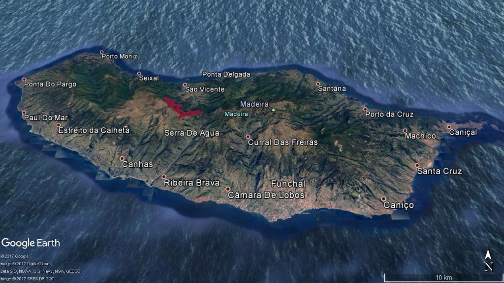
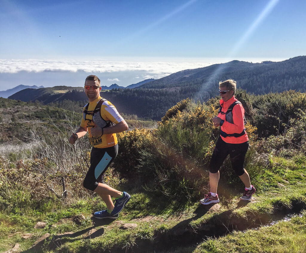
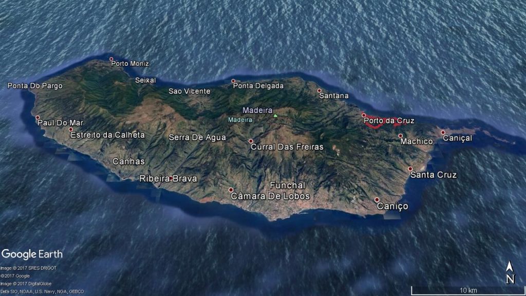
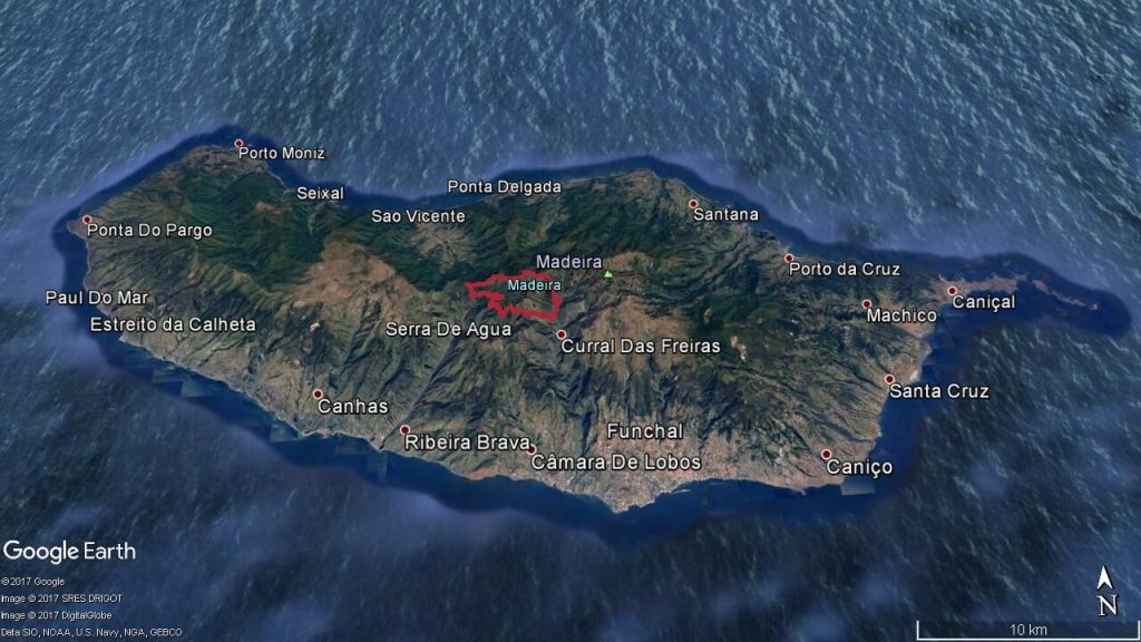
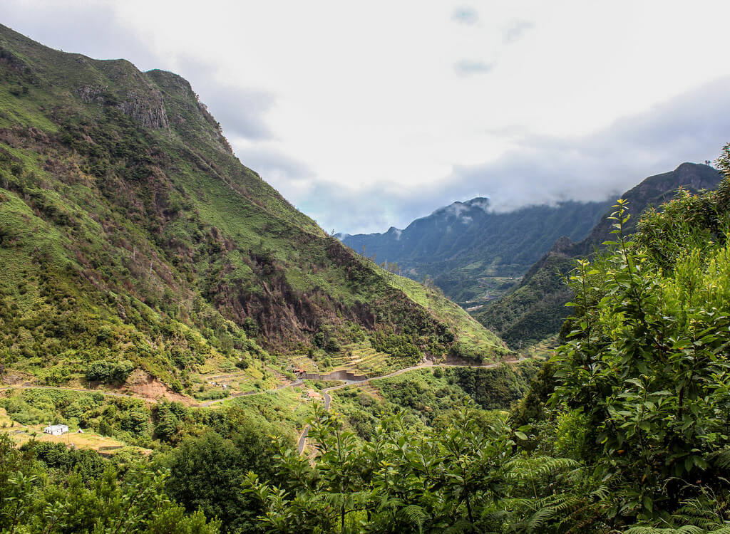
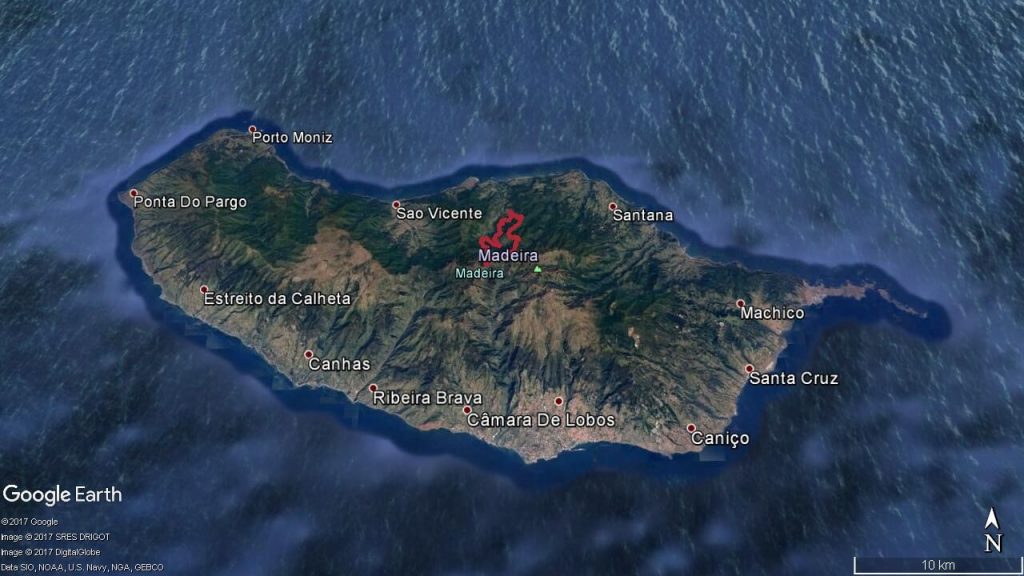
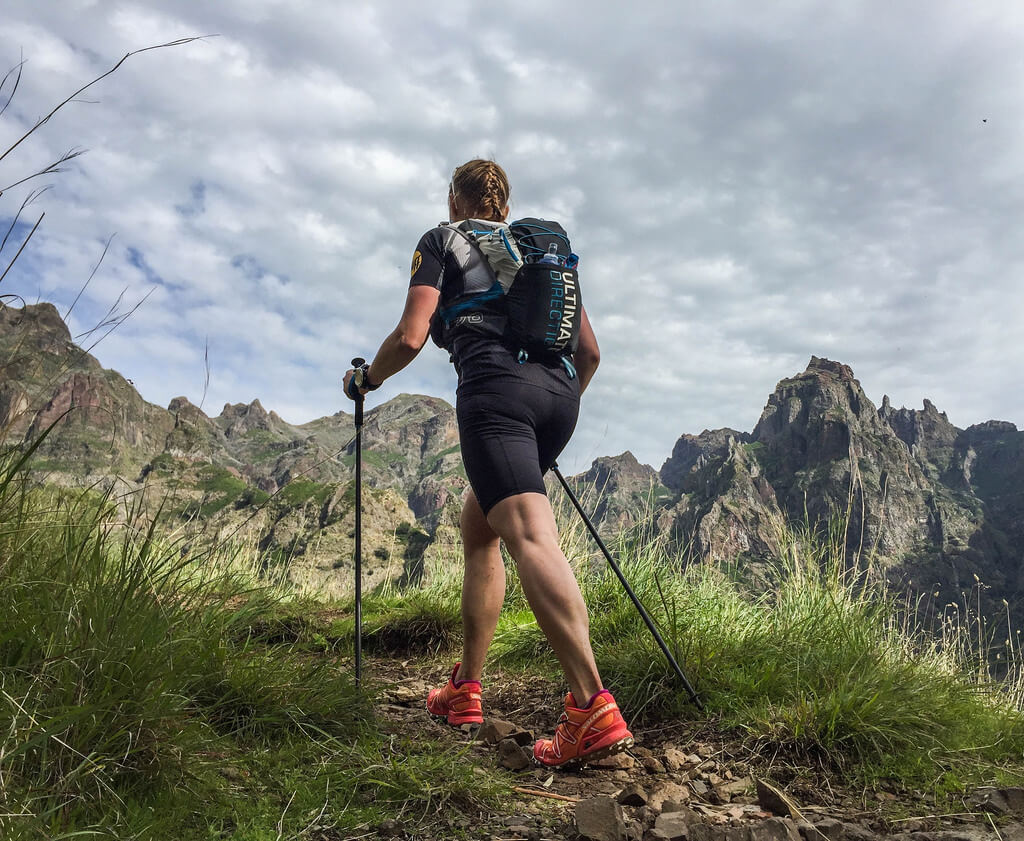
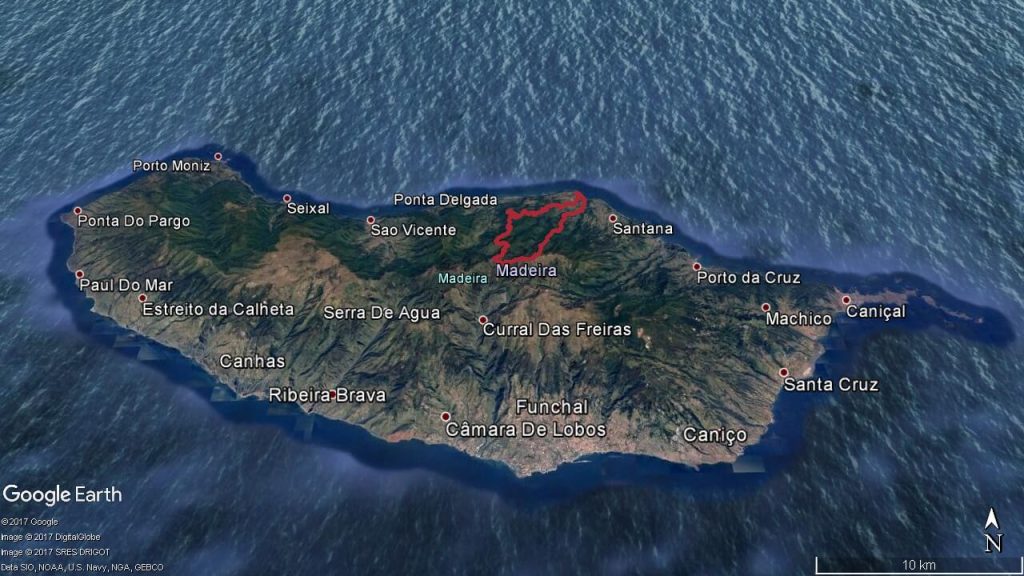
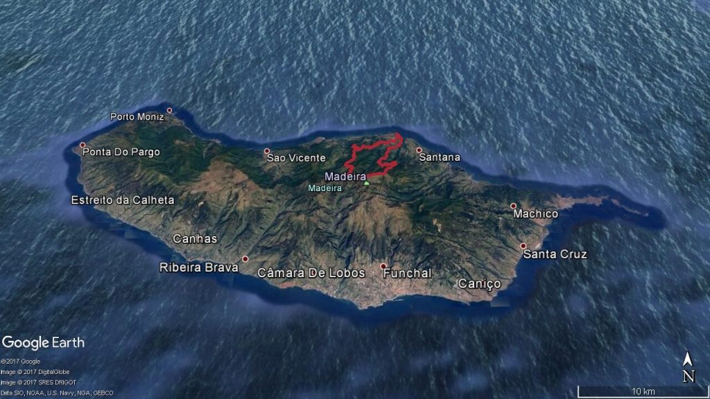
If you still didn’t put Madeira Island on your holiday map, it’s time to do it. This amazing island offers unforgettable experience, especially for visitors who like nature, hiking and running. Explore Madeira trail running with one of our guides. Choose the route, make photos at unbelievably nice points, visit natural beauties and feel untouched nature.
Easy routes
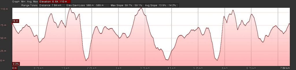
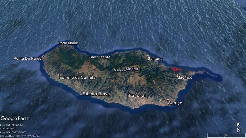
1. Baia D’Abra Trail (Baia D’Abra – Cais do Sardinha – Baia D’Abra)
The beginning of this route is nested at eastern part of Madeira and ends at Ponta de São Lourenço peninsula. Trail goes amongst the cliffs. After climb to the Pico do Furdo at Casa Sardinha, you will enjoy in breathtaking panorama of the Baia D’Abra and the islands of Porto Santo and Desertas. If you choose nice day with fine weather, there is possibility to enjoy in diving at Cais do Sardinha, before you go back.
Elevation gain – 588m
Distance – 7.8km
Altitude min – 6m
Altitude max – 110m
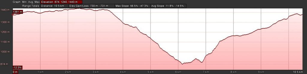
This route starts in Poiso and goes through large pine trees area. At this route you`ll visit Levada do Blandy, Cabeço da Lenha, Poiso basin and São Roque do Faial. The alighting to Ribeiro Frio is realized in a trail over the Laurel forest, and heading in the Levada dos Balcões. Next point you will reach is Ribeiro Frio, where a trout vivarium is situated. After vivarium visit, you will continue to Chão das Feiteiras where you will see a sheepfold. The route ends at the starting point – Poiso.
Elevation gain – 730m
Distance – 10.5km
Altitude min – 874m
Altitude max – 1443m
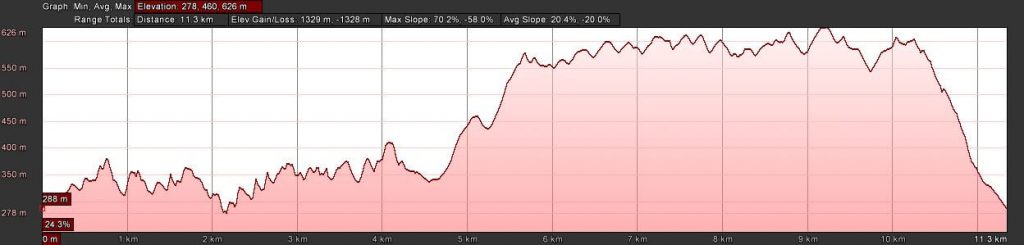
3. Larano Trail (Larano – Boca do Risco – Funduras – Larano)
Starting point of Larano trail run route is in Cabo do Larano. From this place, you follow the Larano trail and enjoy in marvelous surroundings of cliff by the north coast, ocean and mountain views. After you arrive to Boca do Risco you should overcome a short but steep climb. Our success will be prized by getting unforgettable views of the ocean from the mountain crest. Next point is Funduras forest house and you will reach it by dirt road of Funduras, passing through lovely of Laurel forest area. At the Funduras forest house you will enter a spectacular single track which is placed deep inside the dense forest. The last part of this trail is Larano – starting point.
Elevation gain -1329m
Distance – 11.3km
Altitude min. – 278m
Altitude max – 626m
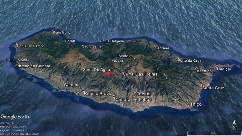
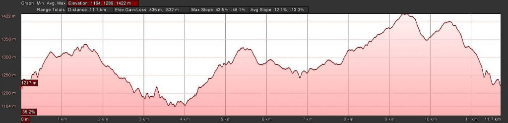
4. Trompica Trail (Boca da Corrida – Trompica – Fonte dos Burros – Boca da Corrida)
You start from Boca da Corrida and the viewpoint is located in the parish of Jardim da Serra. Standing there you can see the highest peaks of Madeira Island, and vivid village of Curral das Freiras, famous for the delicious chestnut cakes locally made from the chestnut trees which is cultivated in the valley. Our first steps on this trail you will make taking a dirt road which goes around the mountains. You will pass through Montado dos Aviceiros and enter ahead in a single track that will bringyouto the Trompica forest house and later to Fonte dos Burros. From this place you can see Serra D’Água, Encumeada, and mountains which surround them. Next step is to check in the highest point. The last part is trail run towards the initial dirt road and coming back to Boca da Corrida.
Elevation gain – 836m
Distance – 11.7km
Altitude min – 1164m
Altitude max – 1422m

5. Chão dos Louros Trail (Chão dos Louros – Rosário – Folhadal – Encumeada – Chão dos Louros)
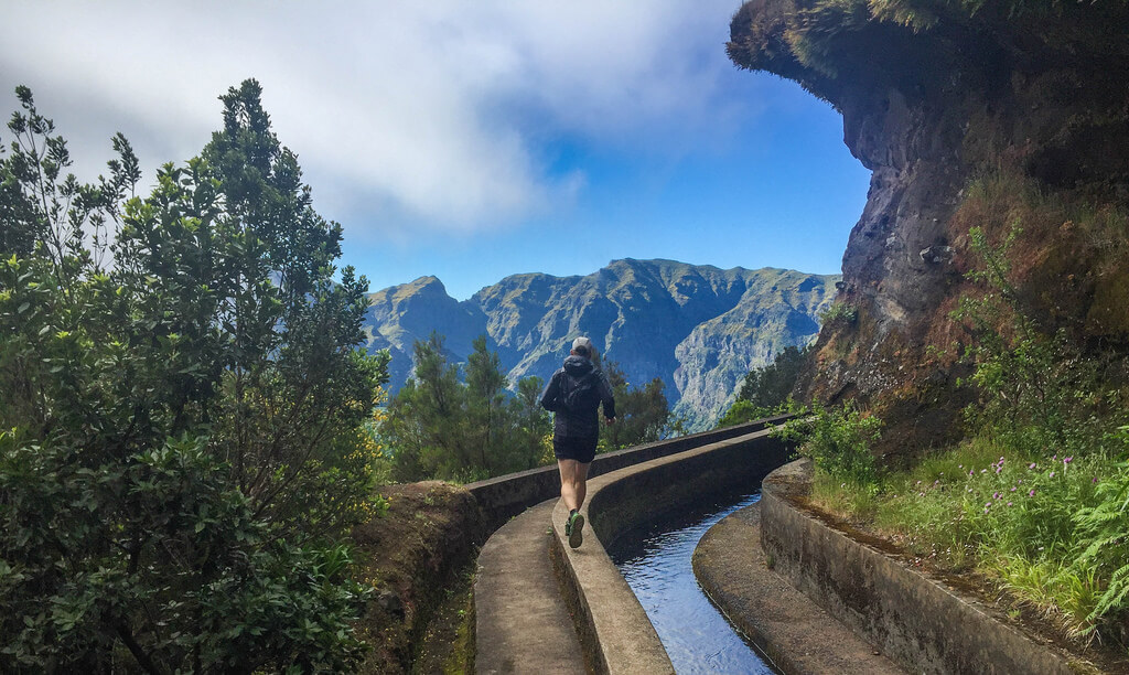
Area of the Chão dos Louros is starting point for this trail. It goes down toward the Rosário, through farmland to Achada do Loural and crossing the Levada do Rodrigues. There you will enter a trail in the Folhadal area that is placed inside the Laurel Forest. After you reach the Levada do Norte, you will continue left and follow to Encumeada. This part of the trail offers the view of the whole valley of São Vicente, the Pináculo and the central mountain ridge of Madeira Island. When you come to Encumeada, you go down again through trails back to Chão dos Louros.
Elevation gain – 1602m
Distance – 13.3km
Altitude min – 424m
Altitude max – 1325m


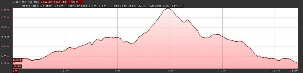
6. Poiso Trail (Poiso – Chão da Lagoa – Pico Arieiro – Levada do Blandy – Poiso)
After you start in Poiso, you go through a grand area that is under the pine trees followed by a single track. Next step is to cross a brook passing to the area of Chão da Lagoa, which is treeless. You will make a bypass to the Chão do Arieiro and after you cross the road, you will continue by an ascent that ends at Pico do Arieiro. When you reach this this peak, you can enjoy in view of the Pico Ruivo, the Paúl da Serra and central mountains of Madeira Island. The descending trail that you will take goes through the Chão do Arieiro and Cabeço da Lenha, well known for planting and preserving native plants of Madeira. During the return to Poiso you will use the initial trail which goes by the Levada do Blandy.
Elevation gain – 673m
Distance – 13.6km
Altitude min – 1372m
Altitude max – 1799m

Moderate routes
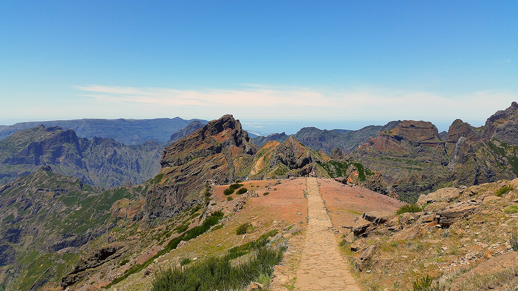
7. Pico do Arieiro Trail (Pico do Arieiro – Pico das Torres – Pico Ruivo – Tunnels – Pico do Arieiro)
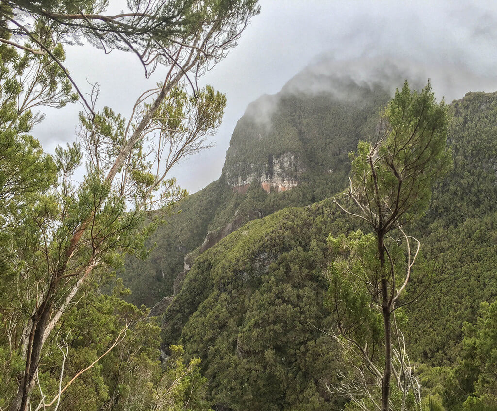
The beginning of the trail is at the third highest peak of Madeira island Pico do Arieiro, at the 1818 m above the sea level. Running this trail, you can enjoy in marvelous surroundings and breathtaking troughs. Along this trail, which is mostly surfaced by stones, for first you will pass the Ninho da Manta viewpoint. Here you can enjoy in a view of the completely hydrographic basin of Poiso and bottom of Fajã da Nogueira. After a break, you continue through the Pico do Gato where route splits and you go right and start with a steep climb around Pico das Torres (1851 m) which is the second highest peak. Next what you will do is to reach foot of Pico Ruivo and begin 200 meters climb to the highest peak of Madeira (1862 m). Standing there you can see the whole Madeira including entire central mountains massif. From this point, you will go back to Pico do Arieiro taking the shortest route, which goes through tunnels.
Elevation gain – 1871m
Distance – 11.5km
Altitude min – 1497m
Altitude max – 1843m

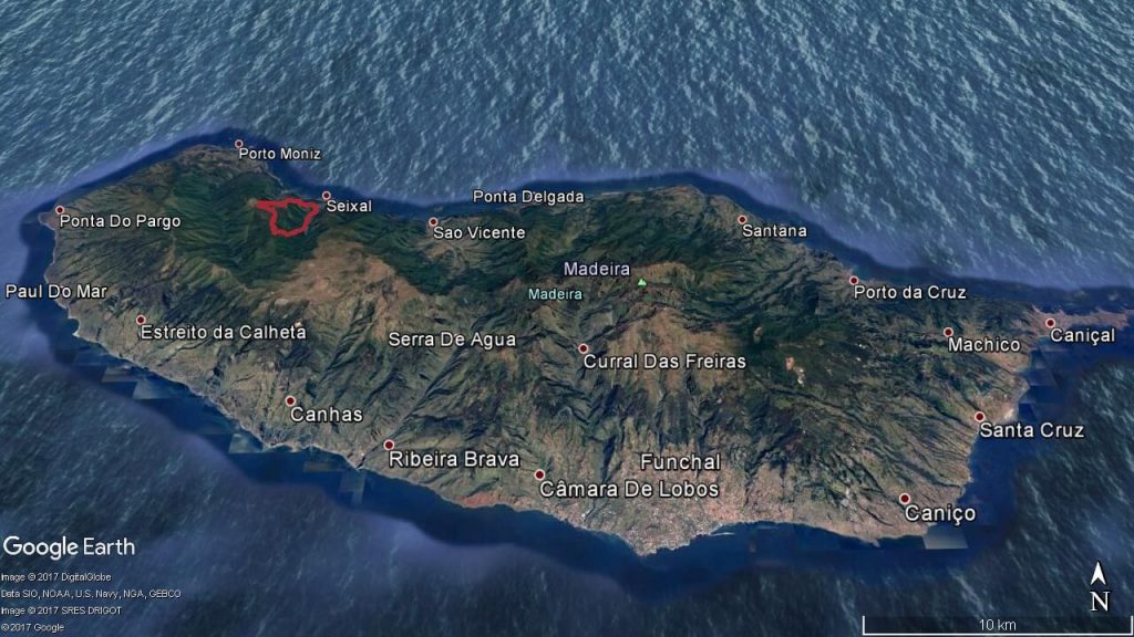
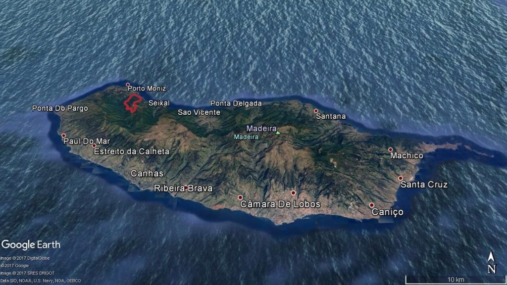
8. Chão Da Ribeira Trail (Chão da Ribeira – Voltas – Fanal – Cavaca – Chão da Ribeira)
Chão Da Ribeira trail starts from Chão da Ribeira which is placed in a deep valley of the great mountains in the north of Madeira Island. From this point, you are going to Vereda das Voltas following an endless zigzag ascent trail through the Laurel forest and coming out on the road of Fanal. Here you are entering a dirt road that will bringyouin Fanal. After Fanal you will continue to Fio, following a trail called the Vereda da Cavaca. It’s important to know that this trail is made up of mud, leaves, stones and roots. It can be dangerous but it’s also beautiful. Maximal attention is required here. In the end of the trail you are coming at the starting point – Chão da Ribeira.
Elevation gain – 1162m
Distance – 13km
Altitude min – 356m
Altitude max – 1290m

Meeting point for this this trail is at the stunning viewpoint of Ribeira da Janela which is placed in the path of Tranquada. From this point, you head along the path to the Castanheiros and climb 500m up the hill to Fanal. While you are climbing, you can see change of vegetation type all around. After you enter the Laurel forest, you will arrive at the top near the pond of Fanal, also well known as a rest and silence reserve with gazing animals. Then you follow the Levada dos Cedros and get across 6 km until you come to Curral Falso. At Curral Falso, you start with the descent to the Ribeira da Janela. This path is almost entirely made of wooden steps.
Elevation gain – 1485m
Distance – 15.5km
Altitude min – 388m
Altitude max – 1159m

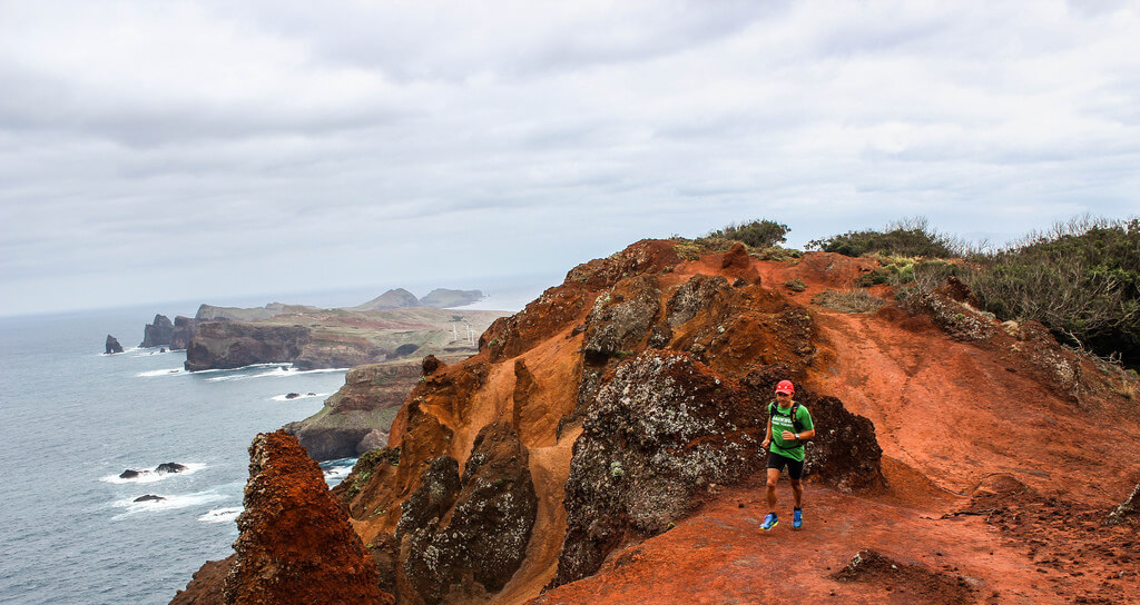
Many visitors think this is the most beautiful trail because it starts near sandy beach of Machico. From this point the ascent, takes you among houses before you enter trail that ends at Pico do Facho. Climbing this uphill, you will get a great opportunity to enjoy in a view of this town. The path goes through Levada do Caniçal towards Boca do Risco. After you pass Boca do Risco, you will climb to Pico das Roçadas. This place is also well known as a point of beautiful view of the north coast cliffs of Madeira Island. Next stage is descending to the village of Caniçal, which will host you with fresh sea breeze. After you reach Ribeira do Natal, you will take the ascending path that goes between the slopes and bringyouat Caniçal and Machico. From this path it’s possible to see airplanes approaching to Funchal international airport. After you come back to Pico do Facho, you follow a descent that ends next to the Santa Casa da Misericórdia de Machico. From this point, you continue by the road and some steps towards the beach of Machico.
Elevation gain – 1413m
Distance – 17.8km
Altitude min – 5m
Altitude max – 496m

11. Folhadal Trail (Encumeada – Folhadal – Pináculo – Lombo do Mouro – Encumeada)
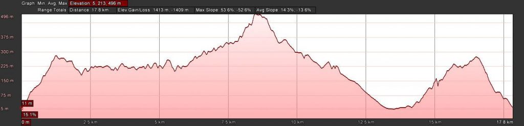
This trail starts from Encumeada. It goes to the opposite direction of Levada do Norte and after you pass a long tunnel, you continue to follow the Levada do Norte penetrating the dense Laurel forest. You pass by some more tunnels before start ascending to the Paredão. Along this part of the trail, you have to overcome about 200 wooden steps that require some muscular endurance, but when you arrive at the Paredão you will enjoy in a beautiful view of Madeira. This will be a real prize for the effort. Standing at the heart of the Laurel forest surrounded by green hills, you will enjoy in lovely views of São Vicente valley. When you continue run towards the Lagoa do Caramujo you will take the dirt road of Ginjas and climb to the Pináculo. From here, you will go down to the levada until you reach the road in Lombo do Mouro. At the end of ups and downs you will go back to Encumenada enjoying in fantastic view of Ribeira Brava, and the central mountainous massif.
Elevation gain – 2331m
Distance – 18.2km
Altitude min – 925m
Altitude max – 1509m

This trail is starting in Poiso and from there you are going through an area covered by large pine trees. It is interesting that after you enjoy in shades of trees you continue through the treeless area called Chão da Lagoa. You will make a bypass around Chão do Arieiro, cross the road and enter an upward trail that ends at Pico do Arieiro. When you reach this peak, you can see the Pico Ruivo, the Paul da Serra and the whole central mountain massif of Madeira Island. From this place, you will take a descending path that goes through the Chão do Arieiro, and Cabeço da Lenha. Next route is the descent to Ribeiro Frio. It guides you to the Laurel forest, and heading to Balcões. From here you arrive to Ribeiro Frio. The ascent is made by a royal stone road through the Chão das Feiteiras. It ends at the starting point- Poiso.
Elevation gain – 1237m
Distance – 19.7km
Altitude min – 876m
Altitude max – 1801m
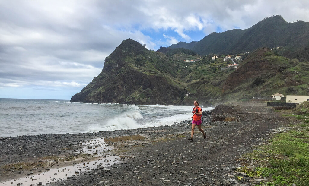
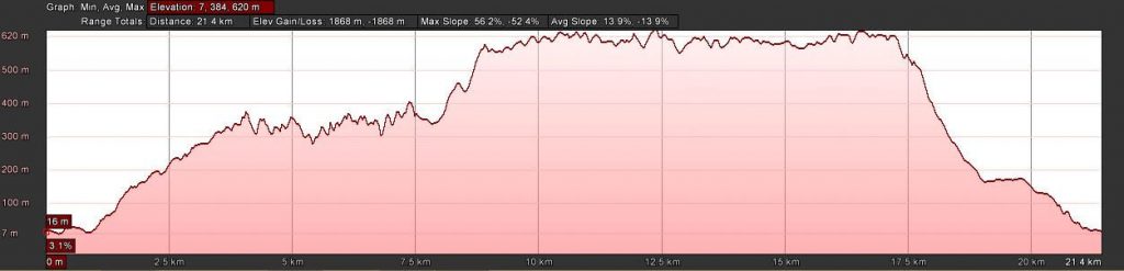
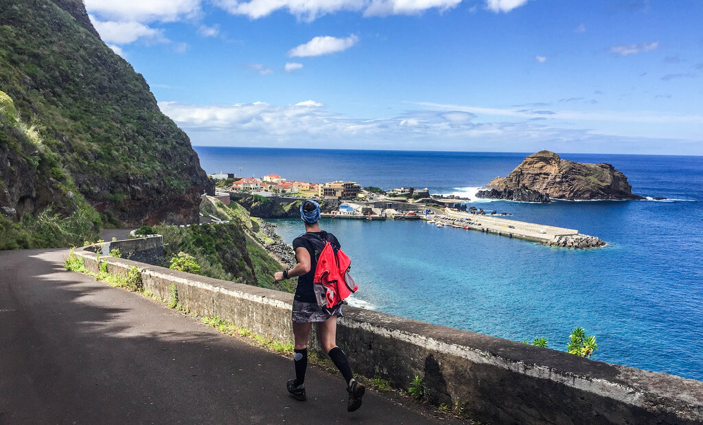
The start of this route is next to the Alagoa beach in Porto da Cruz. It goes along the ocean coastline right to the Maiata Beach. From Maiata beach the trail goes up until you reach Larano zone. Larano trail is located in the middle of the mountain, where you can enjoy in a spectacular ocean view before you reach Boca do Risco. After you pass Boco do Risco you go an uphill. This part of the trail is hard, but it is at the same time marvelous because you enjoy in breathtaking views. You continue through a dirt road until you come to the Funduras forest house. Entering here, you take a single curving track over the mountains and you reaching the dirt road again that leads you to Portela. In Portela you will enjoy in one of the most beautiful views of Porto da Cruz and whole Madeira Island. The downhill is nested in ancient Royal Path 23, leads you through some urban trails, steps and roads down to Porto da Cruz village and ends in Alagoa Beach.
Elevation gain – 1868m
Distance – 21.4km
Altitude min – 7m
Altitude max – 620m
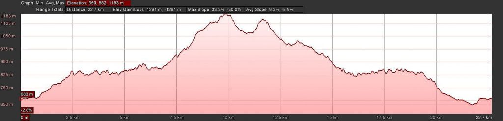
Santo de Serra trail route starts in the parish of Santo António da Serra and follows a dirt road until the Levada da Serra do Faial. After 2 km of running you leave it and pass beside the Pico do Suna and continuing to ascent up to the zone of Terreiros. In Terrieros you enter a trail which has access to another dirt road. Next part of the trail is entrance to another trail with ascending, after which you continue running to the Chão das Aboboreiras, and enter again the Levada da Serra do Faial. After you get across about 4km in Levada’s urban area and reach the center of Santo António da Serra you get back to the starting point.
Elevation gain – 1291m
Distance – 22.7km
Altitude min – 650m
Altitude max – 1183m
Hard routes
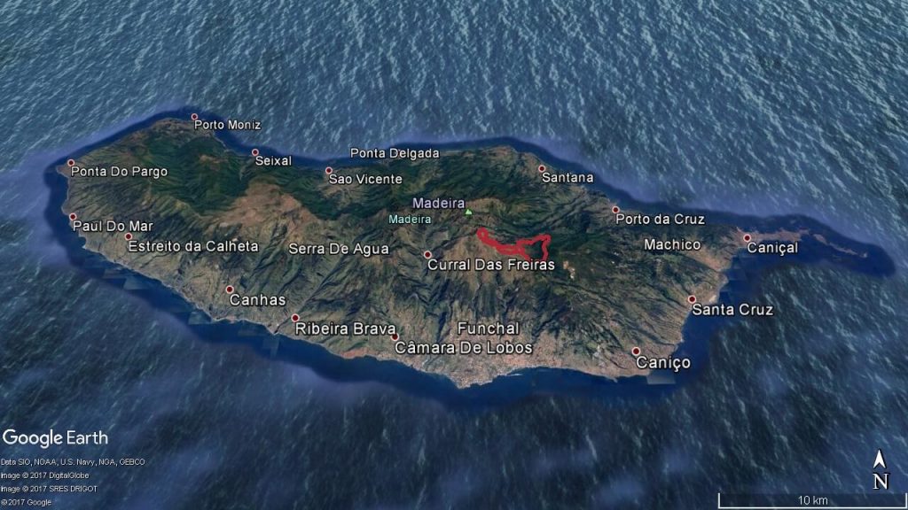
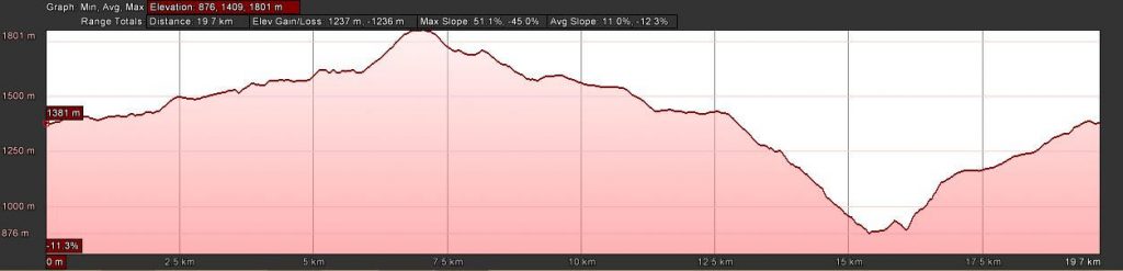
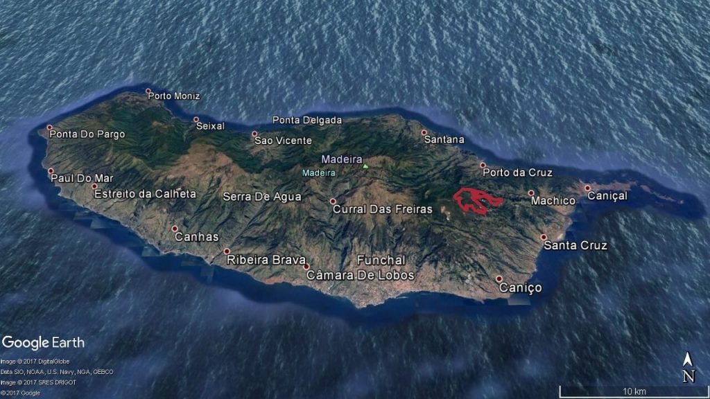
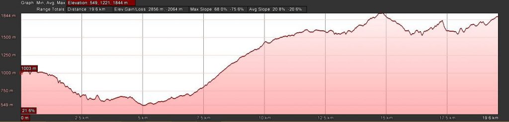
The beginning for this trail is in Eira do Serrado, beside a local hotel. Right from this place, you start the descent rocky zigzag trail and along this climbing you will have a marvelous view of Curral das Freiras village all the time. After you reach center of the Curral das Freiras, you follow through a path to Fajã dos Cardos where you will enter a trail that goes through agricultural plantations. Next part of the trail is ascending to Boca das Torrinhas. Here you will make a stop for a few minutes to admire the Curral das Freiras valley and mountains that surround this place. After that, you will continue running towards Pico Ruivo and uphill about 200m to reach the peak. From this point, you can see almost the entire Madeira Island. After a short stop, you will come back down, passing through the Pico Ruivo shelter. The track goes through several tunnels and across some of the highest mountains of Madeira. When you come to Pico Gato, you will face one of the steepest staircases on the island, constructed with basaltic rock fragments. After the strenuous ascent, through the crest of a mountain with an abyss from both sides, you reach the viewpoint of Ninho da Manta where you can see the entire hydrographic basin of Poiso. This trail is ended at the Pico do Arieiro, the third highest peak of Madeira.
Elevation gain – 2856m
Distance – 19.6km
Altitude min – 549m
Altitude max – 1844m


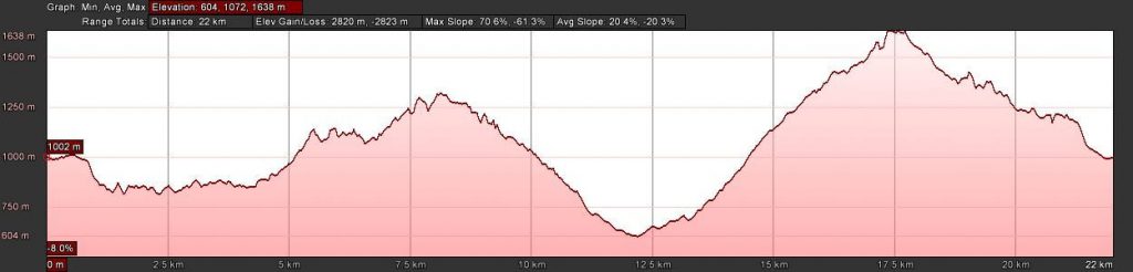
The start of this trail is at Encumeada. This is the border of the north and the south of Madeira Island. The trail begins with an easy passing through Curral Jangão and rising gradually on the South side of the central mountain massif to the Chão das Relvinhas. After this point the trail is going down to Fajã Escura, in Curral das Freiras. When you reach the road to Fajã dos Cardos, you will enter the trail surrounded by agricultural plantations. Along this part of the trail you will enjoy in the shadow of a large eucalyptus trees until you reach Boca das Torrinhas. Here you will make a short stop for and enjoy in lovely view of the valley of Curral das Freiras and the mountains that surround it. Next stage of the route is made of constant ups and downs and basaltic steps of the mountain massif. Final point is Encumeada.
Elevation gain – 2820m
Distance – 22km
Altitude min – 604m
Altitude max- 1638m

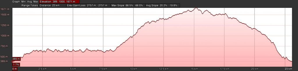
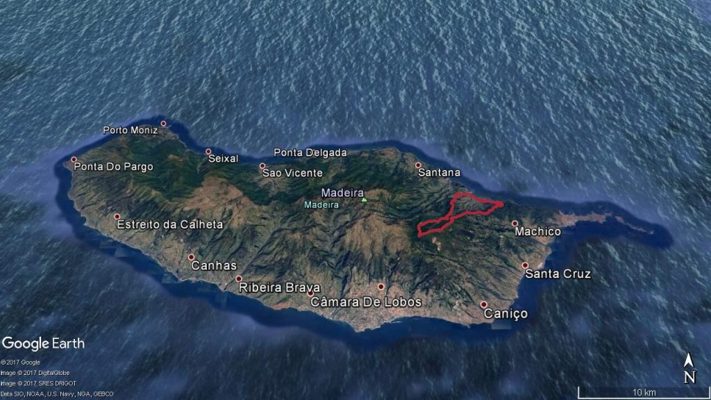
17. Urzal Trail (Fajã do Penedo – Lombo do Urzal – Boca das Torrinhas – Pico Canário – Fajã do Penedo)
This track starts from Fajã do Penedo, Boaventura that is located in parish on the north coast of Madeira Island. The beginning of the route is a path with a smooth climb towards Levada dos Tornos. After you pass some hills in the Lombo do Urzal the levada you will cross a long, but fabulous uphill that ascends to Boca das Torrinhas. You run towards Pico Ruivo traversing part of the central mountain massif. Here you are entering a trail that leads to Pico Canário. Here you have a slight climb and you continue running along trails, passing through Pico do Milhafre, and climbing after to Pico Canário. At this place unforgettable view of Pico Ruivo waits for us. After that you take the route which goes along descending trail until you reach a dirt road. At the end you come at the starting point.
Elevation gain – 2757m
Distance – 23km
Altitude min – 389m
Altitude max – 1671m
Start of this trail is next to the Alagoa Beach in Porto da Cruz. From this point, you take ascending a path and follow the steep road to Terra Baptista. After that, you begin with a long climb up to Pico do Suna, a small trail that ends at the Levada do Furado. You follow it right and go through the levada until it crosses with the Levada do Poço da Bezerra. Then you go up in to Chão das Feiteiras. From Chão das Feiteiras you climb by an ancient Royal stone route which is covered with trees. When you come to Poiso you take descent trail behind the Poiso forest house which is crossing the road a few times and heading for a dirt road where you turn left. You continue running down and pass through Pico do Suna. You come to Lamaceiros. Here you can see a large pond of water storage that is used for agriculture irrigation. Further down you arrive to the view point of Portela. Here you can have a great view of entire Porto da Cruz. Following the road and footpaths, you arrive at beautiful Maiata Beach where you finish the run in the center of Porto da Cruz.
Elevation gain – 2135m
Distance – 29.7km
Altitude min – 8m
Altitude max- 1404m


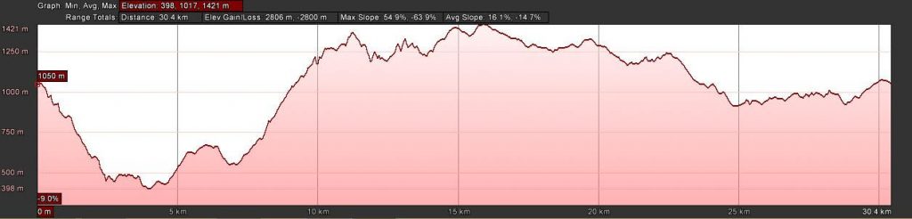
The route starts from the viewpoint Boca dos Namorados. Immediately at the beginning of the route, you can enjoy in a picturesque view of the Curral das Freiras village. After you collect such a good impression of the surroundings, you begin descent to village through a long technical trail and come in the Lombo Chão. When you come to the center of Curral das Freiras through paths and road segments, you continue to the place of Fajã Escura. Here you enter a long uphill trail with a marvelous view of the highest peaks of Madeira Island. Next, you come to Relvinhas. Here you turn left and continue along the trail running up and down over basalt stairs to Boca da Corrida. At this point, you will enjoy in a beautiful panoramic view of Curral das Freiras from a different perspective. In Boca da Corrida there is a forest house where you can refill water, and after that you continue through dirt road to Jardim da Serra mountains through the Chão dos Terreiros, and then by Montado dos Aviceiros on a dirt road. Here you enter a single-track trail that goes straight to the Trompica forest house. From this point, you follow the dirt road to Fonte dos Burros. There’s one more great point where you will take a break and enjoy in a stunning views of the Serra D ‘Água valley, Paúl da Serra plateau and Encumeada. After a short break you take an alternative dirt road and again you enter a trail that leads you back to Chão dos Terreiros. From this place you enter a trail in the Montado dos Aviceiros, after you turn left to find the Levada do Jardim da Serra.
Elevation gain – 2806m
Distance – 30.4km
Altitude min – 398m
Altitude max – 1421m
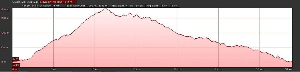
At the beginning of this trail, you are running from Calhau de São Jorge to the old bridge where you are coming to a dirt road and start our ascent to Ilha parish. After that, you follow the road until the entrance to an ascending path; you are crossing a few times some dirt roads through the laurel forest of Madeira. When you reach Vale da Lapa you go to the Levada do Caldeirão Verde and continue climbing until you reach the path that leads to the highest peak of the island – Pico Ruivo. From this point, you will follow the path that goes along the central mountain massif. You pass through the Pico do Milhafre, and climb to Pico Canário. Here you can have a great view of the Pico Ruivo. From this point you continue taking the trail which is descending. You come to a dirt road leading to viewpoint of Voltas, where you have a view of the village of Boaventura. One more dirt road guides you to the forest house of Cascalho. Next few tens of meters through agricultural plantations will bring you to the Jogo da Bola, and then you take descending through the Fio stone path steeped in the hillside towards Calhau de São Jorge.
Elevation gain – 3092m
Distance – 34km
Altitude min – 18m
Altitude max – 1844m
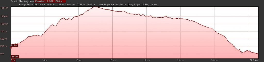
The starting point of the trail is in the center of São Vicente. From this point, you run uphill to a narrow levada. During the next route, you are going further along a dirt road in the area of Ginjas and climb up until you get on a trail heading to levada Fajã do Rodrigues. You continue until you reach the access road to levada in Achada do Loural. From this point you go up a trail in Folhadal which is inside the laurel forest. After you come to Levada do Norte, you go right following this levada and reach the stairs to Paredão. There are more than 200 wooden steps that you have to cope. After this ascending, you reach the heart of the laurel forest, surrounded by green hills. Here you can enjoy in fantastic panoramic views of the São Vicente valley. After a short break, you continue running to Caramujo. When you reach dirt road of Ginjas, you go up until you reach the Estanquinhos forest house. Here you follow a dirt road that leads you to the plateau of Paúl da Serra. Our next point to reach is Pocinhas where you find the Fanal road. You follow this road for a few tens of meters before you enter the path of Fanal. Next 11 km of running, you enjoy in fabulous view on the Rabaçal, the Ribeira da Janela, and the Chão da Ribeira. After you pass Fanal, you go down by a technical trail crossing some dirt roads. The final part of the path guides you to Ribeira da Janela and along former regional road to the village of Porto Moniz.
Elevation gain – 2356m
Distance – 36.5km
Altitude min – 0m
Altitude max -1585m

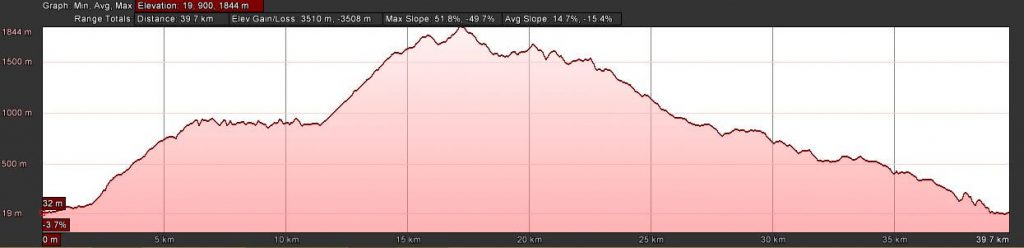
The start of this trail running is in Calhau de São Jorge. You cross the old bridge and come to a dirt road where our ascent starts. There are endless amount of steps waiting for you and guide you to Ilha parish. From this point, you follow the road until the entrance to an acceding path. You should cross a few times some dirt roads before you reach the laurel forest of Madeira. In Vale da Lapa you find the Levada do Caldeirão Verde, and follow it to the left towards Queimadas. Running along this levada you will see waterfalls and a whole immensity of green laurel forest. At Queimadas you tart ascending towards Pico Ruivo. Next part of the route goes along the central mountain massif. You are passing through the Pico do Milhafre and climb to Pico Canário, where you will find a lovely view of the Pico Ruivo. From this point, the trail is descending, until you reach a dirt road leading to viewpoint of Voltas. Here you will enjoy in a view of the village of Boaventura. You will continue along a dirt road again and reach the forest house of Cascalho. Next short distance you are going through agricultural plantations until you reach the Jogo da Bola. After this place you continue along descending through the Fio stone path steeped in the hillside towards Calhau de São Jorge.
Elevation gain – 3510m
Distance – 39.7km
Altitude min – 19m
Altitude max -1844m
+ 9 Bonus Routes
Trail Running Events Test Runs
23. Santana – Madeira Trail Series
Santana – Madeira Trail Series takes place in the municipality of Santana, located on the Northern Coast of Madeira Island and the trails are entirely in the parish of São Jorge, with absolute respect for nature. São Jorge is a land of unique landscapes and is equally interesting as far as natural and historical heritage is concerned, being a must visit local in Madeira!
Elevation gain – 1394m
Distance – 22km
Altitude min – 273m
Altitude max – 843m
24. Ribeira Brava – Madeira Trail Series
From the sea to the hills, between pathways, levadas, native fauna and flora and viewpoints we find idyllic landscapes that offer unique trails and an unforgettable trail running experience!
Elevation gain – 2128m
Distance – 24km
Altitude min – 9m
Altitude max – 1328m
25. Boa Ventura
The Boa Ventura Trail is a trail running event which takes place entirely within the charming Boa Ventura parish, in the county of São Vicente, located in the north of Madeira Island.
Elevation gain – 2539m
Distance – 25km
Altitude min – 40m
Altitude max – 889m
26. Machico – Madeira Trail Series
Madeira isn’t only a sea and mountain paradise with mild climate all year round: it is also a paradise for mountain and nature sports and Machico, located on the northeast coast of the island, is no exception!
Elevation gain – 2481m
Distance – 26km
Altitude min – 9m
Altitude max – 623m
27. Sky Trail Camp Porto da Cruz
The trails are mainly mountainous, with great gradient and bumpy floor. Around 80% of these trails run through Laurisilva Forest, amazingly preserved in this municipality. The trails go all around Porto da Cruz, beginning by the sea and going up until 1400m high (on the 35Km trail).
Elevation gain – 2512m
Distance – 35km
Altitude min – 8m
Altitude max – 1403m
Porto Moniz is known for its magnificent saltwater natural pools made of volcanic rocks, which excel by their beauty and peculiar origin. Porto Moniz is also the home of 67% of the Laurisilva Forest of Madeira, a true enchanted forest, full of native fauna and flora and with very ancient origins dating back 20 million years.
Elevation gain – 4234m
Distance – 47km
Altitude min – 14m
Altitude max – 1472m
29. Ultra Trail Câmara de Lobos
The trails are mainly in mountain and hilly environment and run through the five parishes of the Câmara de Lobos municipality: Câmara de Lobos, Curral das Freiras, Estreito de Câmara de Lobos, Jardim da Serra e Quinta Grande. The Ultra Trail also passes briefly through the municipalities of São Vicente and Ribeira Brava.
Elevation gain – 4389m
Distance – 47km
Altitude min – 347m
Altitude max – 1641m
30. Ultra Trail Porto da Cruz Natura
Located in the Northeast coast of Madeira Island, the parish of Porto da Cruz, in the municipality of Machico, is rich in history and traditions and has a breathtaking landscape! Gifted with an incredible natural beauty, having the Atlantic Ocean as its Northern border and mountains as its Southern border, Porto da Cruz is a privileged location for trail running.
Elevation gain – 3921m
Distance – 48km
Altitude min – 3m
Altitude max – 1403m
The Ecotrail Funchal Madeira is considered the toughest one, due to being extremely hilly, and shows the exceptional natural conditions of Madeira for nature sports and trail running
Elevation gain – 4770m
Distance – 80km
Altitude min – 7m
Altitude max – 1802m
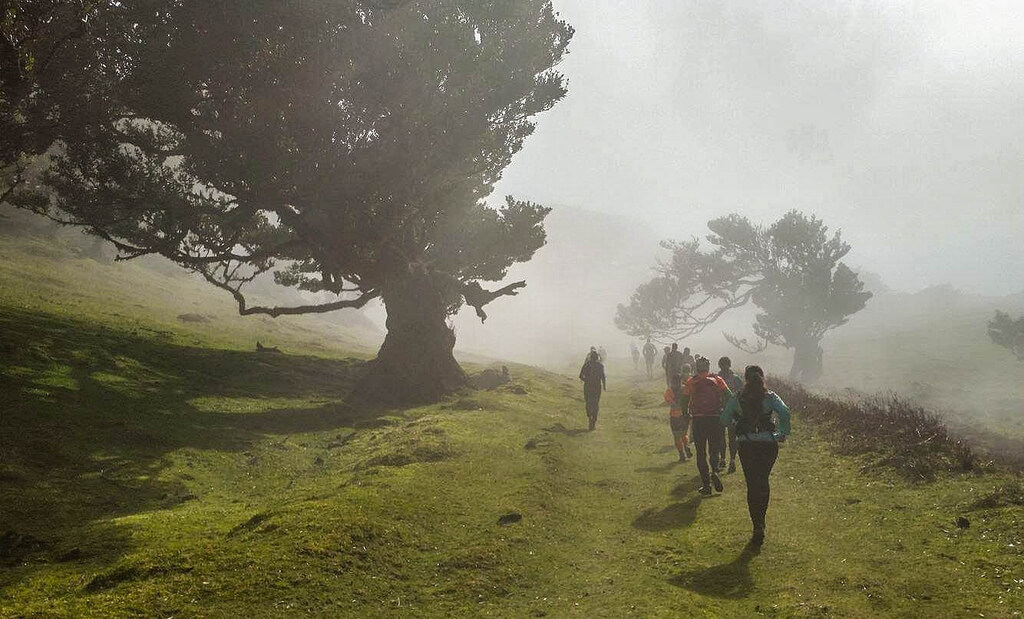
Experience Madeira trail running! Visit beautiful villages, run along incredible paths and trails, enjoy breathtaking views, fell special nature… Choose one of our trails and get an unforgettable adventure! Island of Madeira awaits you!